W. Lisbon Avenue's Plank Road
Plank Road
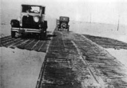
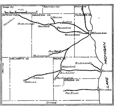
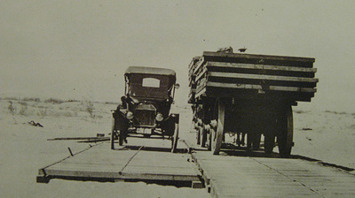
Originating in Europe, plank roads were an effective and efficient means of transporting goods to outlying countryside as well as flourishing cities. In the United States, plank roads were created on already-established dirt trails. During the "Plank Road Craze," which consisted of a three-year span in the mid-19th century, the plank road was the most utilized route for transportation. Indicated in the map of Milwaukee County, the plank road connected major ports along Lake Michigan to outlying cities such as Fond du Lac and Watertown. The roadway typically was wide enough to carry a single cart or car, giving reason to create outcroppings every so often that allowed vehicles to pass one another. Wood planks were typically used such that a flat and even surface could be created over a long distance to create ease in traveling. Plank roads slowly became abandoned due to the wood planks needing frequent repair and, in some cases, even replacement due to rot.
In 1869, the early State Legislature declared the transformation of these slowly abandoned plank roads into an asphalt paved state highway system, establishing the State Trunk Highway System in 1917. This highway system tended to cut directly into major cities, intersecting the typical grid-like street plan. Being the most direct route, the highway system would penetrate to the heart of the neighborhoods at various points throughout the city, bringing goods as well as lots of life to these areas. Cutting through the heart o the cities created lots of growth among these neighborhoods, which brought an explosion of commercial ventures for businessmen, typically tending to the community through thriving businesses such as shops, taverns, and theaters. While the Plank Road was transforming from an abandoned wooden road to a state highway system, the mode of transportation was also evolving. From the early stages before the 18th century, a wagon pulled by oxen was the most utilized means of transporting goods. Business was the typical obligation of travelers on these roads, and travel times tended to be fairly significant. It was not until 1909, when the streetcar was developed, that traveling and transportation of goods on the plank road took on a whole new meaning. More efficient and faster travel times meant a spread of new land development to outlying countryside, allowing residents to commute longer distances to work. The invention of the automobile in 1905 expanded the idea of transportation and seems to mark a significant milestone with traveling for pleasure. People could now travel from an outlying township into the heart of a neighborhood to enjoy dinner, catch a flick at the theater, or simply visit relatives; this soon brought a boom of life to neighborhoods such as Washington Park. The transformation of the Lisbon Plank Road, as well as the ever-changing modes of transportation, affected the Washington Park area a great deal, creating a densely populated community that was full of life. The transformation of the road from wood planks to pavement in addition to the evolution from an ox-and-cart to an automobile created an economic explosion within the community, allowing for many thriving businesses, shops, and theaters to stay intact for many years. The roadway acted as a gateway to the inner neighborhood, slowing the tempo of travel once inside the community to partake in business or even enjoy any of the various local amenities. The Lisbon Plank Road is a major asset to the establishment of this thriving neighborhood. |
Learning Topics
|


Steuben Square
Historically, the intersection of W. Lisbon Avenue, N. Sherman Boulevard, and W. Lloyd Street has always been an important place in the region of Milwaukee that is now known as Steuben Square in the Washington Park neighborhood. W. Lisbon Avenue first started out as trails that led Native Americans to their inland cornfields. As Milwaukee began to be settled, a plank road was created to improve transportation through the region.
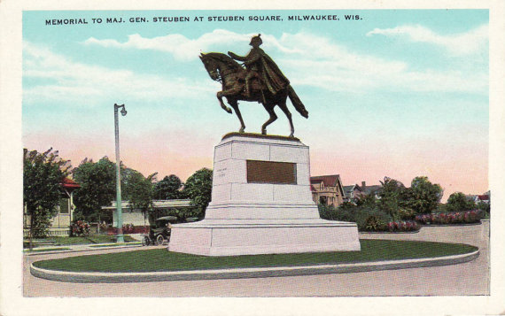
When the grid of Milwaukee's streets was implemented, W. Lisbon Avenue had become such an integral part of the transit that it was left unaltered by the master plan until 1899, when the planks were removed, and it became a paved street. The plan further affected W. Lisbon Avenue by creating an intersection of two more roads -- W. Lloyd Street and N. Sherman Boulevard. When Frederick Law Olmsted designed Washington Park in 1891, it gave greater importance to the intersection of these streets. The intersection becomes the first glimpse into the park the visitors see as they drive south on these streets. This gives more importance to the site, as it becomes the moment when the park and its entrance are revealed from all these roads. This importance has caused this intersection to become a main entrance into the park for accessing the north end of the site. A statue was commissioned in 1921 to be placed on the median strip of the intersection. The statue was commissioned by the Steuben Society and was to be of Baron Frederick Von Steuben, a German military commander who helped the United States during the Revolutionary War and the man after whom the intersection is named. The library was the last anchor point to be added to the site. The original library was built three blocks north of Steuben Square, on W. North Avenue, in 1953 but was relocated to its current site in 2003 and designed by HGA Architects. The library is an important part of the community, as it is one of the few libraries in the area. As a result, Washington Park Library is utilized by a large population of the neighborhood's residents and helps to anchor the site into the fabric of the community in the present, while the park and the statue hearken to the past. |
Learning Topics
|